A model ride through Rolleston-on-Dove, by rail:
To best view the line, settle down in one of the two non-corridor carriages that make-up the “Tutbury Jinny”, the train that gave its name to the nature trail following the route of the line between Rolleston-on-Dove and Stretton & Claymills after closure. Having left Tutbury, the auto coach leading, the “Jinny” has taken the right-hand track at Marston Junction. After crossing the River Dove, Dove Junction is traversed, before travelling over Station Road Bridge.
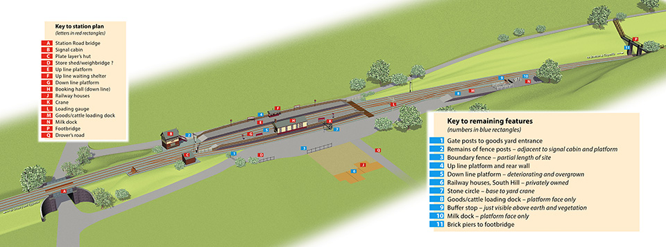
No images of the original road bridge exist; built for the opening of the line in 1848, it was severely damaged by flooding in October 1875. The report states that the situation occurred in part due to the roadway having been lowered to give adequate headroom under the bridge. A temporary single track track timber structure carried "piloted" rail traffic while a permanent replacement was being built. The replacement bridge received the inspector's seal of approval 28th March 1876. In had stout supporting brickwork tapering upwards with buttresses on each side, to compensate for the roadway not being at right-angles to the track. Four capped wings retained the earth embankment. A photograph taken in 1965 shows the original span replaced and the brickwork taken down to track level. It is reported that the steel work was replaced during the early 1920's when a forge was established in the roadway below and the blacksmith would throw the white hot rivets up to the workers re-building the span. The 1875 bridge was selected as the prototype to be modelled; a photograph taken around 1910 being the main source of information for the plans.
To the right, adjacent to the shunting spur, the simple brick-built plate-layer’s hut comes into view. Two photographs, taken by a camera pointed at other subjects, were the only reference for this building hence detail on the east and south sides only is accurate. There is no evidence of a chimney although a coke stove would usually have been an essential item in such a building.
Immediately to the left is the signal cabin. Built for the opening of the station - 1st November 1894, this typical North Staffs cabin contained 26 levers, but would only be opened for the shunting of the goods yard. An excellent reference photograph of the cabin, taken shortly before its demolition in 1952, by F. W. Shuttleworth, appears in a number of books, the viewpoint proving ideal for preparing the elevations from which the model could be constructed.
Once past the signal cabin, the platforms begin and the train draws to a halt. The prototype up line platform remains complete with rear brick wall, the gap to accommodate the shelter having been filled with brick from the opposite platform wall when the buildings were demolished during the sixties. What better reference could one have! Measurements were transferred directly to the model with little need for shortening; the North Staffs were generally modeller-friendly when planning the length of platforms.
Both platform buildings were timber framed with overlapping fascia boards; as the plans indicate, these plans were developed initially from a handful of period black and white photographs. The current models are in fact the second attempt as more accurate reference materialised at a later date. Made up of four main rooms, the booking hall consisted booking office, waiting room, ladies room and gentlemen's facility, accessed from a door at the north end of the building. Due to the position of the goods loop to the rear, entry to the building had to be from the platform.
Timber-built waiting shelters, constructed by the NSR tended to be of similar design, but the example at Rolleston has tended to be unique in featuring an enclosed front with a door for entry. On examination of its remaining footprint, the surface suggests that it comprised two small rooms, one of them containing a small stove. Early photographs reveal a chimney pipe and a grate from a coke stove was unearthed close-by at the time of the restoration.
Re-starting from the station, a glance to the right reveals the goods loop with accompanying hand-operated crane and loading gauge. No reference is available for the crane, loading gauge or store shed and weighbridge, which the official plans indicate. Both crane and loading gauge are built from commercial kits and considered as accurate as possible to their originals. A little delving along the path of the present day nature trail reveals a stone circle - the foundation for the crane. A representation of the store shed only materialised recently following a visit from a gentleman who's father worked for the railway and occupied one of the three railway houses. On asking him about the store shed, he gave a detailed verbal description of the structure, so it is now included as part of the model but without a weighbridge.
Behind the goods yard an iron fence marks the boundary with South Hill and remains in part today. Three gateways give access to the railway company dwellings occupied by stationmaster and staff. One gateway is wider and gives access to the "drover's road", a track for the herding of livestock from Craythorne Lane to the station cattle dock. A later resident of the stationmaster's house reported that this building included a ticket window so either passengers had a choice of where to purchase a ticket or the facility may have been used for freight/parcels documentation.
Leaving the platforms, to the right, the carriage/cattle dock spurs off from the goods loop. A short dock, it accommodates four wagons and adjoins an end-loading facility for the purpose of propelling road wagons or carriages on or off flat railway trucks. The prototype buffer stop of a type suitable for end-loading survives, so reference gathering in this area could not have been simpler.
The track plan at this location is not the original; following the inspection of the station complex at the time of opening, the inspector raised concerns that passengers had to cross the goods loop at the north end to gain access to the platforms. The suggestion to move the booking hall to the southbound platform and vise versa did not prove feasible, but shortly following opening, extra pointwork had been installed at the north end of the site enabling wagons to be propelled into the carriage/cattle dock directly from the main line, alleviating the need to negotiate the foot crossing at the north end.
In reality the line entered a deep mile-long cutting before the reaching the next station, Stretton & Claymills. During the building of this line, earth dug to create the cutting was transferred to the other side of Station Road to create an embankment or beyond Stretton for that of the Hawkins Lane branch.
Rolleston’s original compliment of signals was four lower quadrant home units, products of McKenzie and Holland. These would only be turned to danger when shunting operations were in progress. All were replaced with upper quadrant types in 1951during the BR period.
The final feature is the footbridge built for the Thornewill family to link Dovecliff Hall with Craythorne Hall, both in their ownership. Only the brick piers remain, the lattice iron span, possibly a product of local engineering company Thornewill and Wareham, having been removed during the sixties. Advantage has been taken of "modeller's license" by moving this structure close to the carriage dock due to restricted space.
Next stop: Stretton and Claymills.